Aggregates
Solar Power
Wind Power
Availability & Curtailment
Power Site Weather
Rooftop PV
Additional Weather Data
Irradiance Sensors
Irradiance Maps
.CSV files
Site Map
Other Resources
Welcome to the University of Arizona Power Forecasting website.
You're seeing this text because something went wrong loading the page. It could be a problem on our end or it could be a problem with your browser. Please contact Ian McNichols (ifmcnichols@arizona.edu) or Leland Boeman (lboeman@arizona.edu) with questions. We recommend using Chrome to view our site. Recent versions of Internet Explorer and Firefox will also work with our site.
Welcome to the University of Arizona Power Forecasting public data page.
Select a data source using the menus above.
This page is made possible with support from Tucson Electric Power, Arizona Public Service, and Salt River Project.
About this site
This site shows selected point forecasts from recent WRF model runs from the UA Power Forecasting Group. We welcome your suggestions, but please know that this site is not funded and is mostly maintained in our spare time. This site is the beneficiary of websites created for renewable power forecasting for TEP, APS, and SRP.
The forecasts on this page can be used for any purpose so long as they are attributed to the University of Arizona. We hope that you will let us know if you use them. We make no guarantees of availability or accuracy.
Please consider supporting our work if you find this page to be useful.
Contact information
Contact Patrick Bunn (ptwbunn@arizona.edu) Leland Boeman (lboeman@arizona.edu) with any questions.
A tour of the site
The site loads with an overview panel of WRF model predictions for Tucson, Phoenix, Flagstaff, and Yuma. Click on "Toggle 1 day / Multi day view" in the upper left corner to toggle between a rolling 24 hour plot of forecasts and actuals, a 2 day forecast, and an 8 day forecast. Your browser is supposed to remember your choice between visits. Your browser will automatically reload the images every 5 minutes.
Click on any image to open it in a new page. This too will automatically reload.
You can see all information for a single sensor by hovering over the "Environmental data" menu and then selecting a sensor. Clicking on "Home" will take you back to the overview page.
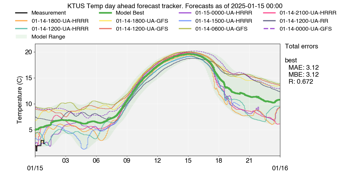
The first image is the rolling 24 hour plot of forecasts and actuals. This plot is updated every ~20 minutes and the plot creation time is indicated in the title.

The second image is the 2 day forecast starting at midnight MST. This plot is only updated when new model runs are available.

Next, we have a wide plot with a 7-8 day forecast. We run one model per day out to 8 days, and it is initialized on the 0Z GFS. Remember, we're showing model range, not uncertainty. There's a big difference.

A few words on the green model range envelope, the mean, and the median. The model range is the +/- 30 minute rolling mean of the +/- 30 minute rolling min/max. The same procedure is used to calculate the model average. We do not apply any smoothing to median.
We will consider adding csv files of the forecast data if there is sufficient interest.
Other resources
The "Other resources" menu provides links to the main UA WRF site and local radar images and satellite images.
More about the forecasts
See the UA WRF page at weather.arizona.edu for the latest WRF model runs. See the Power Forecasting Group's main page at weather.arizona.edu for more information about us.
How are the plots created? A lot of Python and a little bit of bash.
We have 10s of TB of archived WRF forecasts. Let us know if you're interested in using them in a study.
Land Acknowledgement
We respectfully acknowledge the University of Arizona is on the land and territories of Indigenous peoples. Today, Arizona is home to 22 federally recognized tribes, with Tucson being home to the O’odham and the Yaqui. Committed to diversity and inclusion, the University strives to build sustainable relationships with sovereign Native Nations and Indigenous communities through education offerings, partnerships, and community service.
Click an icon to get more information about that station/system. If available, forecasts for that station/system will be shown below. Most weather station forecasts are only available on the public webpage. Power forecasts are not available to the general public.
Click the Weather Stations, Solar PV, Solar CSP, and Wind checkboxes to hide or show the icons for that station/generation type.
Click the Scale icons checkbox to make the icon area proportional to the peak power of that generator.
Use the Weather Station Type menu to control the variable shown in the forecasts below (if available).